Research Highlights
Video traffic analysis for abnormal event detection
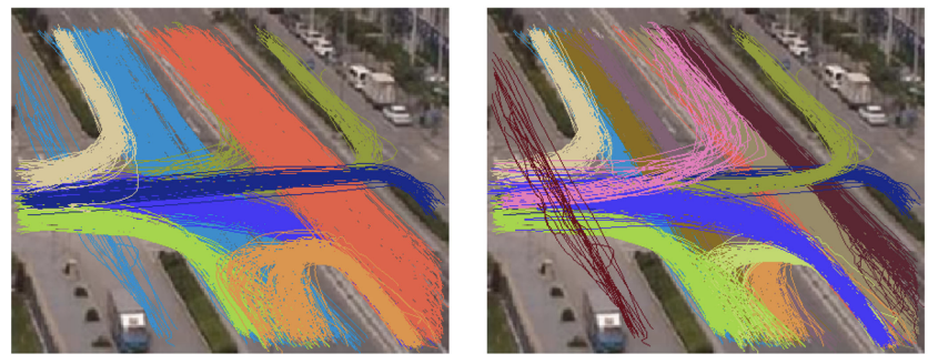
Visual traffic analysis using computer vision techniques can be non-invasive, automated and cost effective. Traffic surveillance systems with the ability to detect, track and classify the behaviours of vehicles can be effectively employed in various situations and achieving a promising traffic control capability in well controlled and structured circumstances. However, vehicle behaviour analysis can be compromised in complex traffic circumstances, e.g. clutters and occlusions, and therefore it is compelling to develop a new automated system which enables us to reliably and consistently locate the position and activities of every vehicle in complicated scenes. In this project, we will design a new and automated system in order to correctly track multiple vehicles in a camera network, reliably cluster motion trajectories of the vehicles into different categories and robustly predict the events of the vehicles in crowd scenarios. To evaluate the proposed system, we will recruit two databases that can be publicly accessible or purchased from top research groups working in this research area. The performance of the proposed system is also compared against that of the other state of the art techniques available in the community.
Automated analysis of housing construction progress through remote sensing
This project aims at developing and testing image processing tools specifically designed to map the various development stage of new housing sites. Leveraging the short revisit time allowed by existing constellation of satellites like e.g. Planet, this will potentially allow the accurate identification of construction timeline. The specific questions the project will investigate are: Can we detect different stages of construction from high resolution satellite imagery? What are the stages of construction that we can detect and what levels of confidence can we attach? Would the solution be cost effective? As this is primarily driven by the cost of commercial satellite imagery, which is essentially determined by ground resolution, this actually means: what is the minimum ground resolution allowing the detection of construction stages? Is it necessary/desirable to know in advance where construction is expected to take place? How does this affect the prediction confidence? Could this be used to detect potential unauthorised construction activity?